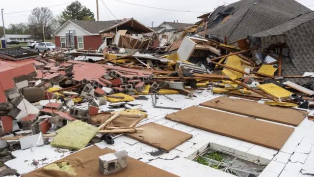
Numerous tornado warnings and at least two flash flood emergencies were issued to begin the weekend, putting the country’s heartland at risk of destructive thunderstorms and flash floods once more on Friday.
With multiple tornado reports and water rescues, communities south of St. Louis, Missouri, and east of Dallas seemed to be the most severely affected.
Without accounting for the effects of more rain on already saturated land, strong thunderstorms posed a hazard to over 55 million individuals.
One of the earliest supercells developed over the Red River Valley on Friday afternoon.
No initial reports of injuries were made, although there was significant damage to structures in the Clarksville, Texas, area.
Storm reports from the National Weather Service indicate that a tornado near Hawkins, Texas, caused by another major supercell further east, damaged residences and a bottling business.
Coincidentally, it was the second occasion in the past ten years that a twister had affected the Hawkins-area business.
Thankfully, no serious injuries were recorded.
Before the thunderstorm activity moved east of the Mississippi River, more tornadoes were reported in Missouri and Arkansas.
A stalled weather pattern, which has brought major and fatal severe weather for the Mississippi and Ohio valleys over the workweek, is responsible for the rounds of thunderstorms.
Even while Wednesday’s severe weather event, which resulted in over 600 reports of wind, hail, and tornadoes, was more widespread than Friday’s, the risk of flooding is still rising since thunderstorms are still forming over some of the same locations.

The area is affected by potentially fatal flooding.
Deadly flash floods hit the southern Ohio Valley from Arkansas and Missouri due to the slow-moving front’s recurrent storms.
According to forecast models, much of the region may have an extra 3–5 inches of rain by the end of the rainstorm, with other locations perhaps receiving far more.
Some localities have already received more than a foot of rain, so any more will just make the already high rivers and streams worse.
The weather pattern has been maintained by ridges of high pressure along the Eastern Seaboard, but these are gradually disintegrating, allowing the rainfall to finally affect places that have not received significant precipitation.
This change will put an end to the region’s damp and steamy weather by allowing drier, less humid air to pour in.
The flooding won’t go away anytime soon, even though the possibility of drier weather is good news.
For the near future, river levels will be high, and any further rainfall might be troublesome if a rainy weather pattern returns.
This information has been sourced from Fox News.


Leave a Comment