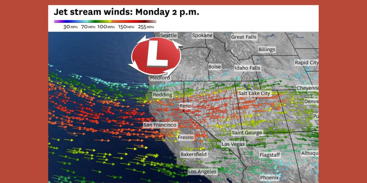
The National Weather Service issued severe turbulence warnings for portions of California and Nevada on Monday morning as an early spring storm grew stronger and blew across Palisades Tahoe with gusts of up to 150 mph.
By combining strong mountain snow that might pile up to five feet in some areas of the Sierra Nevada by Tuesday night with high-speed gusts, these extreme winds—especially from the jet stream—created the conditions for a major weather event.
A weather balloon taken off from Reno at about 5 a.m. Monday recorded gusts of more than 170 mph at about 33,000 feet above the ground.
This reported wind speed set a new record for this late storm season stage and was the strongest jet stream winds for this time of year in Reno.

Such strong winds are uncommon for this time of year, according to weather balloon measurements going back to 1956.
These powerful upper-atmosphere winds were driving a powerful storm system over the Pacific Ocean from Asia to North America, which improved the likelihood of severe snowfall and erratic weather in the Sierra Nevada and neighboring regions.
At an elevation of around 30,000 feet, jet stream winds over Northern California are typically predicted to reach 60 mph in the early spring.
However, as was the case on Monday, storms have the ability to propel these speeds well above 100 mph.

The Bay Area saw even more powerful gusts as the storm developed, with jet stream speeds predicted to reach over 170 mph.
These winds would break the existing records for this time of year if they occurred, demonstrating the unusualness and intensity of the weather.
The powerful jet stream had beneficial benefits on air transport, especially for trips over the Pacific, but it also created dangerous circumstances in the highlands.
For instance, the strong tailwinds helped a number of planes from Hong Kong to San Francisco International Airport, with some landing almost an hour ahead of schedule, according to flight tracking website FlightRadar24.
The weather service warned of significant turbulence in the Sierra Nevada, particularly below 14,000 feet, on the ground.
On Monday afternoon, this turbulence was predicted to be especially hazardous.
Firefighting planes attempting to put out a wildfire near Bishop on Sunday night were actually grounded due to the extreme winds.
Both commercial and emergency planes had to fly in hazardous conditions due to the wind’s severity and the hilly terrain.
Severe Storms Sweep Through Midwest, Killing 7 and Stranding Hundreds of Thousands Without Power
As lenticular clouds, which are stationary clouds created when moist, stable air encounters a barrier, emerged above the Bay Area on Monday afternoon, the turbulence and strong winds were evident in the sky.
Strong atmospheric instability is evident from these clouds, which serve as a visual cue of the extreme turbulence pilots and people passing through the area were encountering.
Furthermore, heavy cirrus clouds—which are frequently linked to jet stream activity—moved quickly across San Francisco Bay, indicating that the storm’s effects were still being felt.
It became evident as the storm pushed across the area that the confluence of strong winds, a lot of snow, and turbulence was an uncommon and hazardous meteorological phenomenon that would have a significant impact throughout the West Coast.
As the storm progressed throughout California and Nevada, locals and visitors were advised to remain vigilant, as there could be more interruptions in the mountains and the skies.
This information has been sourced from sfchronicle.


Leave a Comment